Search CAP

CAP Trail

CAP Trail

The CAP Trail provides a recreational opportunity throughout the state. The trail is for multiple non-motorized recreational uses: walking, jogging, equestrian, cycling and roller blading.

The vision for the CAP Trail started when CAP construction began in the early 1970s, and development of the trail is dependent on partnerships with local jurisdictions.

CAP does not have legal authority to build or maintain the trail; in fact, cooperation and partnerships among municipal, county, and tribal agencies determine the outcome of the trail. There are more than 30 organizations that have been, or will be involved in, getting the trail constructed, each sponsoring a portion of the trail that runs through their jurisdiction. CAP facilitates these recreation agreements between the U.S. Bureau of Reclamation and city or county sponsors to help with the prospective sponsors’ councils or boards, planning commissions, and trail committees.

Click on the icons below for more information, including printable maps.

CAP Trail Map

CAP Trail from Waddell to Lake Pleasant

Waddell to Lake Pleasant
North Phoenix
*Approximately 4 Miles

CAP Trail from County Line to Tangerine

County Line to Tangerine
Pima County
*Approximately 8 Miles

CAP Trail at Pyramid Peak Parkway

Pyramid Peak Pkwy to Happy Valley Road
North Phoenix
*Approximately 9 Miles

CAP Trail at Nona Road Trailhead

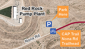
Nona Road Trailhead to County Line
Pima County
*Approximately 9 Miles

CAP Trail from Cavecreek to Scottsdale

Cave Creek Road to Scottsdale Road
North Phoenix
*Approximately 7 Miles

As construction of the CAP began in 1973, the United States Bureau of Reclamation anticipated the development of the multi-use recreational CAP Trail. Wherever possible, Reclamation acquired sufficient land and inset the fence 10 ft. to 20 ft from the property boundary to allow for a trail to be developed. Emphasis is focused on urban areas, particularly in those areas where the trail could be developed in conjunction with adjacent development.

As development continues to occur adjacent to the canal, CAWCD requests that each municipality and/or developer provide an additional twenty feet of trail width or setback along those adjacent developments to allow for proper grading, drainage and landscaping enhancements to occur on the developers property.

In order to help facilitate the construction of the CAP Trail, the CAWCD Board developed the following trail policy:

  • The CAP recreational trail is planned on the unfenced strip of land (approximately twenty feet wide) between CAP’s canal security fence and its canal property boundary line. The general trail location is on the downhill side (south or west) of the canal in the Phoenix area, west of the canal in the Pinal County area and on the uphill (east) side of the Pima County area but switches sides in specific locations. The trail is planned for multiple recreational uses; i.e., walking, jogging, equestrian use, bicycling, and roller blading if paved. However, public motorized uses will not be allowed.
  • The recreation trail shall be outside CAP’s security-fenced “closed” aqueduct system for operational, security, maintenance and liability reasons. CAP preserves its right to use the planned trail area for the maintenance of the CAP security fence.
  • CAP will facilitate the recreation agreements between the city or county cost-sharing sponsors and Reclamation; this facilitation will include working with the prospective sponsors’ councils or boards, planning commissions, trail committees, and Reclamation. CAP will move the security fence where necessary for trail width if feasible from an operational perspective. CAP may also contribute such work as landscaping in advance of trail agreements or other activities that will promote and advance trail development.
  • In urban areas CAP will work with each jurisdiction’s planning department prior to review and permitting of new developments adjacent to the trail. CAP will request that the permitting secure an added trail width or setback in areas where less than twenty feet of CAP property is available for trail development. Comments are routinely requested from CAP’s Engineering Department on adjacent new subdivision developments. When reviewing these, CAP will confirm the request for additional width or trail setback in areas that are adjacent to the planned trail.
  • CAP will consider the possibilities of recreation trails for non-motorized use in the areas of CAP recharge projects, particularly the Agua Fria Recharge Project or other recharge projects where CAWCD has ownership of or easement rights to use the land. CAP may initiate, build, or sponsor recreation trail projects on CAP land in these areas, participate with recreation trail plans of other jurisdictions, or facilitate projects with landowners. Recharge project operations, however, retain first priority; any recreational plans considered shall not adversely impact CAP recharge project operations.

Contact the CAWCD Lands Department at 623-869-2555 or by e-mail at 2555@cap-az.com if you have any questions or want to schedule an appointment to discuss a proposed project.

Alert Icon

This link is taking you away from the CAP website and provides information on an external site that is consistent with the intended purpose of the CAP website. CAP cannot attest to the accuracy of the information provided by this link or any other linked site. CAP is not responsible for the information or links provided by sponsors of the site or any products presented on the site. These links do not represent an endorsement by CAP or its directors or employees of site sponsors or products.